A Historical Summary for Coopers Plains
Coopers Plains is the first crossroad of Brisbane. In 1826, a few years since the establishment of the Moreton Bay Penal Settlement, Captain Patrick Logan named land eight miles south of the Brisbane River penal colony “Cowper’s Plains”; an area explored by Logan and by Allan Cunningham in 1828. The honour was to Dr Henry Cowper, the Assistant Surgeon of the settlement. The area that was to become known as Coopers Plains (changing the spelling of ‘Cowper’ and dropping the apostrophe), was a wide flat, ‘walled-in’ from the north and north-east by ridges that flowed off Mount Gravatt. One ridge line runs south through Sunnybank and Sunnybank Hills, up to the heights of Calamvale. Another line runs along Toohey Forest, across Nathan, arches north through Tarragindi (and the back of Moorooka) and up the Annerley ridge, and then steeps up to Dutton Park and Highgate Hill, where it turns towards the river and declines & terminates at Hill End (West End); thus separating the early Brisbane township from the flats of Fairfield, Yeronga, Yeerongpilly, and out towards Oxley, and the Coopers Plains flat which now included the suburbs of Rocklea, Archerfield, and Acacia Ridge. Historically the Coopers Plains area took more than just the flat and included the lower hills that rolled up to the Nathan & Sunnybank Ridges. The twist of fate is that the early Coopers Plains settlement which began on the flat has mostly become the region of Archerfield and Acacia Ridge. The local township, which identifies itself as the contemporary centre of Coopers Plains, has now come to exist in the hills on Orange Grove Road, with its industrial arm taking up the flat between the Beenleigh railway line and Beaudesert Road. There is no longer much of the ‘Plains’ in Coopers Plains.
Over a century and a half, the Coopers Plains centre has been moving in the north-east direction, starting with the first properties in the 1840s around what is now Mortimer Road in Acacia Ridge. Other properties opened up slightly further north where Beaudesert and Musgrave now intersect. Antecedence of the early Beaudesert Road community date to 1828 when the Cowper’s Plains convict outstation was established in an area on Stable Swamp Creek, somewhere close-by to where Musgrave Road now crosses the creek. The convict work gangs were used on the construction of the Limestone (Ipswich)-Brisbane road. When the penal colony closed down in around 1840, the outstation disappeared and a small rural community emerged .The Moreton Bay Racing Club set up their race course in the district in 1843. The community developed as a coach stop between the Brisbane Township and Beaudesert. A school opened on Beaudesert Road in 1869, and was followed a few years later by the establishment of the Rose and Crown Hotel, which served as the first local post office.
When the Coopers Plains Railway station was built around 1885 the township grew up on Henley Street. The first suburban estates provided land sales close to the railway station and mostly to the west of the railway line. The Post Office eventually moved into Henley Street. Around the same time as the Coopers Plains Railway Station community is emerging, an early landowner John Soden subdivided land on the eastern side of Orange Grove Road and the northern side of Musgrave Road, opening it for land sales as the Orange Grove Estate. By the end of the nineteen century Coopers Plains has become centred close to the railway station. In 1898 the old Coopers Plains settlement had been dissolved in the new suburb of Acacia Ridge. In 1924 the Coopers Plains Progress Hall was constructed in Rookwood Avenue. However, in only a few years the drift would continue north-east.
In the early 1930s the second Orange Grove Estate opened for land sales south of Musgrave Road and on the eastern side of Orange Grove Road heading up to the new Orange Grove Road State School on top of the hill. Shops emerged on Orange Grove Road at the bottom of the hill across from the end of Longden and Dartmouth Streets. A number of churches were constructed in the Orange Grove Road community area. In the 1920s the Station United Protestant Church was built in Beaton Street. A Methodist Church was built in 1953 on the corner of Rockwood Avenue and Coopers Plains. In 1942 the Damour Barracks was constructed on the other side of the Coopers Plains State School (renamed from Orange Grove Road State School). The retail and commercial centre on Henley Street, on the other side of the railway tracks, continued to thrive into the 1950s, but by the 1970s it was no longer the major local hub it once was. The Henley Street-Boundary Road community still plays an important part for the suburb, providing unique as well as essential services, particularly being the Post Office site. Orange Grove Road, though, cemented itself as the Coopers Plains Township. The shops on Orange Grove Road expanded in the 1970s and at one time the shops hosted an earlier petrol station on the western side of the road (a recently-built petrol station is now on the eastern side), competing with the long-standing petrol station on the corner of Orange Grove and Boundary Roads. The crowning achievement for the community was the opening of the new library in 1979.
There were other movements in the development of Coopers Plains. In the 1950s there was opening up of the land south of Boundary Road and along the railway line to Troughton Road with 300 housing commission homes constructed for Dutch immigrants. The first shops in the Banoon area on Troughton Road were opened in 1951. Troughton Road, at the south-eastern corner with Musgrave Road, was the site for many years of the Skyline (Coopers Plains) Drive-In.
The movement in the last two decades of the twentieth century has been further north-east along the line that started in the old Coopers Plains settlement around Mortimer Road back in the previous century. Within fifteen years from the time the QE II Hospital was opened on the corner of Kessels and Troughton Roads, the Queensland Scientific Laboratories and the John Tonge Centre (State Morgue) were constructed along the bushland between Middle Street and Kessels Road, creating a biological sciences hub. However, despite developments in the very north-east corner of the suburb, the lower end of Orange Grove Road retains its role as the major suburban centre for Coopers Plains, affirmed when The Village residential estate opened in 1995 on the site of the demolished Damour Barracks.
Dr Henry Cowper and the name of Coopers Plains
A few years since the establishment of the Moreton Bay Penal Settlement, Captain Patrick Logan named land eight miles south of the Brisbane River penal colony “Cowper’s Plains”; an area explored by Logan in 1826 and by Allan Cunningham in 1828. The honour was to Dr Henry Cowper (1800-1849), the Assistant Surgeon of the settlement. Dr Henry Cowper had been appointed in the role on 1 September 1825, only months before Logan’s arrival as Commandant in March 1826 and it appears that that the relationship started well.
Henry’s prospects for being memorialise in Queensland history was good in those early years. He was born to a prominent family. His father William Cowper (1778-1858) became the minister of St Philip's Church, for a period the only clergyman permanently in colonial Sydney. His younger brother, Charles Cowper (1807–1875), was appointed secretary to the Church and Schools Land Corporation in 1826, later to become the noted New South Wales politician and second Premier of New South Wales. Henry, the eldest son, had showed himself as a devoted & respected Christian gentleman, and was assiduously recording the events and conditions of the Moreton Bay Penal Settlement. His medical training and extensive work in the New South Wales colony was, and has since been, highly regarded. Henry played a significant role in the search and recovery of Logan’s body in 1830. And yet he has mostly disappeared from the history record. Unlike his father and younger brother, and his employer (Logan), there are no references in the Australian Dictionary of Biography; not even a passing reference. Alas, poor Henry disgraced himself, and he became a ‘black sheep’ to both the family and Queensland history.
Much of what we know of Henry Cowper’s fall from grace comes from Dr John Fitzgerald Murray, a second Medical Officer appointed in May 1830, who records Henry’s drunken states, his ill-temper, and the settlement’s displeasure at his ‘insane’ behaviour. Logan is recorded as saying that Cowper was ‘his own greatest enemy’. The ghastly end came when Henry Cowper was dismissed by Governor Bourke in December 1832 after an official enquiry into the incident where Cowper and John Richards, the Master of the brig Governor Phillip, broke into the Female Factory and supplied female convicts with rum. If that wasn’t enough, Henry later became insolvent and couldn’t pay off his debts before his death on 5 June 1849.
Whereas ‘Cowper’, the village near Grafton, the New South Wales County, and the Australian Electoral Division, are named after the New South Wales Premier, there is much less distinction for the elder brother in Queensland. There is the Parish of Cowper in the Tablelands region but the author has no information to date on its name origin. There is also a street named Cowper Place in suburban Brisbane that is named after Dr Henry Cowper but that has only existed in the last fifteen years.
Cowper’s Plains – the great plain that stretches out beyond Mount Gravatt & the Nathan-Sunnybank-Annerley ridges, and across towards Mount Lindsey – became known as Coopers Plains, changing the spelling of ‘Cowper’ and dropping the apostrophe. There have been or are other ‘Coopers’ in Queensland. There may have been another Coopers Plains in Maryborough. There is Coopers Camp Road in Ashgrove, on the north-side of Brisbane, and there are few more streets named in honour of ‘Cooper’. Some of these may have something to do with Dr Henry Cowper.
It no longer, however, provided Dr Cowper the prominence he may have hoped for. Much of what was Cowper’s Plains is now suburbs of unrelated names, and the ever-spaning Coopers Plains has ironically dwindled to a suburb mostly on the foothills below the Nathan ridge.
References: Coopers Plains Local History Group. A Closer Look at Coopers Plains. 2nd Edition, May 2005. Pollard, N. S., 'Cowper, William (1778–1858)', Australian Dictionary of Biography, National Centre of Biography, Australian National University, http://adb.anu.edu.au/biography/cowper-william-1929/text2301, accessed 18 July 2011. Ward, John M., 'Cowper, Sir Charles (1807–1875)', Australian Dictionary of Biography, National Centre of Biography, Australian National University, http://adb.anu.edu.au/biography/cowper-sir-charles-3275/text4967, accessed 18 July 2011. Cranfield, Louis R., 'Logan,
Can You Help?
The Coopers Plains History Group (CPHG) has a large archive of photographs, letters, and other documents. From time to time, we need the help of members of the local community to be able to provide information about certain items in the archive. Perhaps you know the item's history or recognise places or people depicted in a photograph or a document. Please let us know, by contacting CPHG member, Simon Cole here.

Origins Project
Being an over-arching examination of Coopers Plains' past to the present.
The Concept: Commandant Patrick Logan of the Moreton Bay Penal Colony named a large plains south of the river peninsula settlement after the assistant surgeon in 1826- 1828, Dr Henry Cowper. The origin of the landscape is hidden in the colonial mindset which was coy about what was reported. The records are extremely thin for the development of the convict depot along the road to Limestone (Ipswich). Furthermore, there was tension between the local Yuggera or Yerongpan (a general term for groups along the Brisbane river westward) and the colonisers. The commandants were sensitive on how much information to send to the New South Wales governors, particularly in frequently requesting more supplies and marines. In 1830 Logan made the ultimate point by being murdered in the upper reaches of the Brisbane river. The project is to describe the original Coopers Plains from the fragments of information from primary sources, evidence from the few sets of colonial records, and the oral histories from the Yuggera or Yerongpan persons.
The Research Strategy: Systematic following through gathered secondary sources, primary sources of the Watson Frederick’s Historical records of Australia (1913), with oral history traditions, and the newspaper report of Coopers Plains in The Australian in 1839, the earliest reference of a public record of the era. Notations taken.
The Writing Strategy: Work with the active historians of the Coopers Plains History Group and Kuril Dhagun in developing and re-structuring from the first full draft manuscript of the reported research into the best narrative that tells the story of the origins and landscape of Coopers Plains.
The Event Strategy: Work with and petition the Brisbane City Council and Queensland state government in 2024 to promote Coopers Plains’ history of the period and Southern Brisbane history more generally. This would involve pre-publication talks, book launches and radio and social media interviews.
List of Outcomes:
- A broader community awareness of the origins Coopers Plains and its significance in the history of Brisbane.
- Recognition and signage of Coopers Plains as the First Crossroad of Brisbane and plaques and monuments placed in significant locations in the area.
- Brisbane City Council and the Queensland State Government credit for promoting Southern Brisbane and Brisbane society to a global standard of knowledge and the heritage memories of the local area.

Convict Station
Cowpers Plains Convict Station
The very first settlement in - what is now - the Coopers Plains area was a convict station outpost of the early Moreton Bay penal colony. It's exact location is uncertain and there is no plaque commemorating it. In "1828 ... the Cowper’s Plains convict outstation was established in an area on Stable Swamp Creek, somewhere close-by to where Musgrave Road now crosses the creek. The convict work gangs were used on the construction of the Limestone (Ipswich)-Brisbane road. When the penal colony closed down in around 1840, the outstation disappeared." Do you know anything about its location? Would you like to help have a commemoration plaque created?

Aboriginal History
The tribes that lived in and traversed across Coopers Plains
Aboriginal history is an oral/aural one, but records and evidence survive in the form of living descendants with handed-down memories, official notes that British explorers and various settlers made as well as unofficial letters, newspaper reports, association minutes and verbal recollections. Our 2005 publication, A Closer Look at Coopers Plains begins with a description of local tribes with information that was available at the time. More recent publications expand on this considerably. These include the Rocky Waterholes & Sable Swamp section of “Indigenous Aboriginal Sites Of Southside Brisbane” by Dr Ray Kerkhove. “Aboriginal history of the Princess Alexandra Hospital site” by Dr Ros Kidd. “Bones and artifacts found in Toohey Forest Park” in the Westender. Do you know anything about our area's indigenous past? We welcome further credible input.
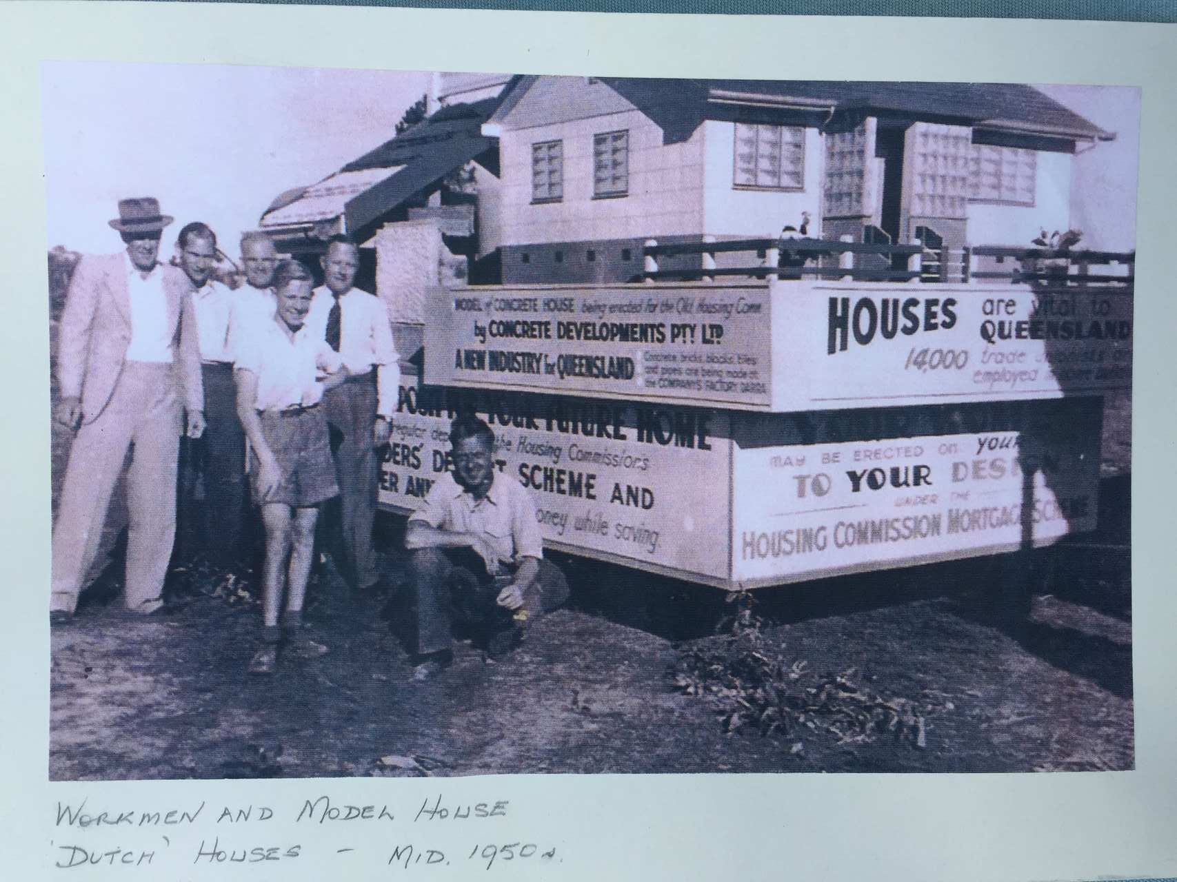
Dutch Houses
The Dutch Houses were built in the early 1950s
We are helping the Dutch Australia Cultural Center (DACC) collect stories from people who are associated with the Dutch Houses of Coopers Plains. The DACC Dutch Houses Story Collection Initiative is open to current residents of these houses as well as Dutch individuals who once lived in them and who are related to those who built them. Our primary goal is to gather stories, especially those related to the early days in the 1950s and the migration experiences of the residents during that period. We plan to showcase these stories on both the DACC website and the Coopers Plains History Group website. If you have a story to contribute, please read the information we already have in the links above and then you can comment HERE or send a email HERE.

Cowpers Plains Medical History
Stories of our medical past

Street Names
Origins & Meanings of Street Names
Building on research by Mary Bishop and Allan Waller (pp 146-150 "A Closer Look at Coopers Plains"). To see this research download this pdf.CPs_Street_Names

Park Names
Origins & Meanings of Park Names
Coopers Plains' premier park is Beryl Roberts Park, named after the former Chair of the Coopers Plains History Group.

Churches
Coopers Plains Methodist Church, c. 1950.
The Coopers Plains Methodist Church was built on the corner of Orange Grove Road and Rookwood Avenue in 1952, and was open in early 1953. The church group of women and children in the photograph was probably taken between 1953 and 1961. Who were the people in the photograph? In what year or date was the photograph taken? Who was the photographer?

Coopers Plains Services Honour Roll 1939-1945
The honour board was created in the late 1940s and originally was held in the RSL Hall in Rookwood Avenue. Any information on names that appear (double-click to look at full size image) and on the creation of the board would be much appreciated.
")
Shops and Stores
Salisbury Store, c.1900?
This photograph of the Salisbury Store, assumingly early in the twentieth century, was donated by Ted Humphrey of Salisbury. It was originally held in the possession of his late wife. In this photograph stands a recently constructed simple timber-constructed store in Salisbury. It is thought to be located on Beaudesert Road in the area where the intersection of Lillian Avenue would appear. The store has two sections, four front windows, and two doorways close to the dirt road. Two women, three men, and two boy pose for the photograph. One boy is mounted on tray with a horse on the left. On the right is a large commercial carriage owned by "D. Jenkins. Confectioner" with the other boy leaning out. What is known about the "Salisbury Store"? Where was its location? Who were the people in the photograph? In what year or date was the photograph taken? Who was the photographer?
World Wars
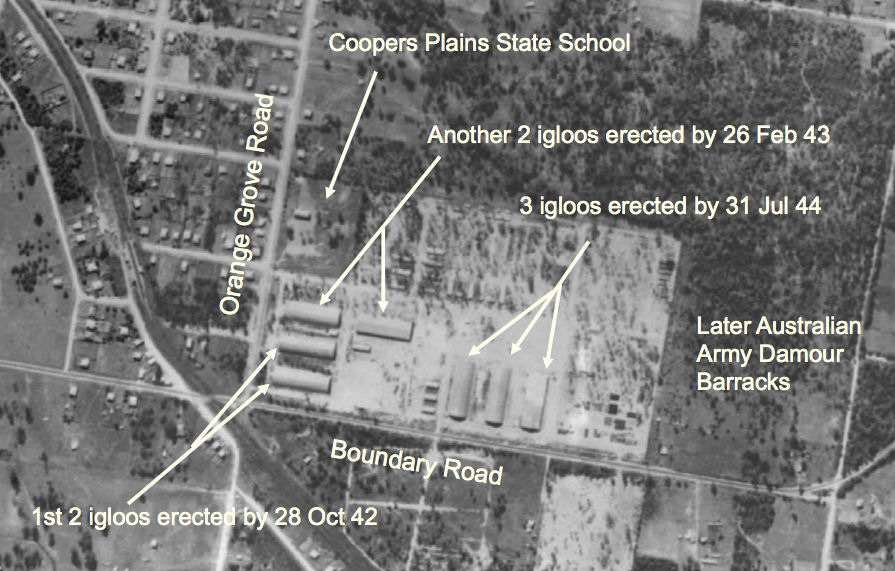
WWII USA Igloos in Coopers Plains
1946 aerial photo showing the development at the Coopers Plains Ordinance Depot. The igloos were used for varying purposes with one igloo being used as a small parts store, another as a reconditioning plant and another as a carpenter's shop that made boxes for the shipment of refurbished small arms. The Depot developed a number of new innovative designs for weapons. The "M15 Special" comprised a Bofors gun installed in a turret on the back of a half-track. Eighteen of these modified weapons were issued to 209th AAA Battalion, which used them as an infantry support weapon during fighting on Luzon. OZATWAR